

The plans around the data and catalogue is to analyse the AFD Censation data (Geodemographic Classification System) of customers that have purchased after receiving the catalogue, and add more customers into future mailings that match the same customer profile.
Censation can be used to provoke penetrating questions and important discussions that lead to new or clearer insights and more confidence in decision-making. These insights can help to shape and style communication in a way more likely to be relevant to the target audience. For retail, charity and local government, the options and priorities for locating stores and services can be more readily assessed.
Perhaps the most obvious application is to append Censation codes to existing customer databases and to look for consistent patterns – a process called ‘Profiling’. Are you particularly successful with customers that fall into certain Censation code groups? Why not look for these codes within your prospect data? Did you expect a different result? How will that affect your future communication?
Alternatively, you may wish to target existing customers with additional offers. To do this you can compare the codes for those customers that have made multiple purchases with those that have only made a single purchase. This can highlight those customers more likely to make a further purchase. To find out which customers are likely to stay loyal, long-term customers, you could compare the codes for those who haven’t purchased in the last twelve months, with those that have.
Censation codes can also be applied in ‘live’ situations. In a call centre, scripts and offers can be adjusted to be more likely to appeal to a caller – based on their postcode and Censation code. Universities can attract applications from targeted social backgrounds by using the codes to communicate with words and styles more likely to be relevant and accessible.
Censation is built using over 600 variables from the latest UK Census, the results of 80,000 face to face interviews per annum and reference to residential and transactional data. All this information is cleverly analysed and condensed into this straight forward system.
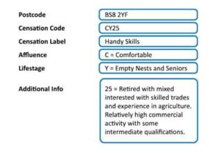
Censation classifies each postcode into one of 52 ‘segments’ each with its own 4 character Censation segment code.The first letter indicates how rich or poor people living in a postcode are likely to be. Are your customers wealthy, prosperous, comfortable, striving or struggling? The second letter in a Censation code indicates the life-stage of your customers. Young singles, young families, older families, families with children who have left home (empty nesters) or seniors. The last two digits of a Censation code highlight distinctive characteristics drawn from the underlying Census, Residential or Commercial data or from research, residential and transaction data. A short additional description is put in descending order with the strongest or most likely attribute first. Finally a detailed supporting table with over 30 different characteristics is provided. Further ‘unclassified’ codes are allocated to postcodes for which census data is unavailable. These mainly describe the make-up of commercial areas.
Geodemographics is the analysis of people by where they live. Conveniently, in the UK we can identify those places in ‘postcode units’ with up to 100 properties on a single postcode.
AFD Refiner an intuitive batch and interactive address cleansing system will easily append Censation codes to contact data. Developers can use the AFD Postcode, AFD Plotter and AFD Postcode Plus API to append Censation codes to customer and prospect data and use the codes for profiling or to make real-time communication more effective.
With AFD Names & Numbers the Censation codes are fully indexed so affluence and lifestyle indicators can be searched, counted and selected. Selections can be further refined using Length of residency and household composition filters. (Data extract conditions apply, please see the license for details) Please note: AFD licenses specifically exclude bureau use. For bureau licensing details please email: sales@afd.co.uk
It’s important to understand that a Censation code simply highlights the fact that when compared with the rest of the UK, people living within a particular postcode are more likely to have the characteristics described by the associated Censation code. The key to using this information sensibly is to start a sentence which says “If I were looking for people with X characteristics I would be more likely to find them within Y Censation Code.” Of course a postcode with a Censation code AW01 (Wealthy, Young Families) may well contain some households who are not wealthy, young families – however, the code signifies that if you are looking for wealthy, young families you are more likely to find them here than elsewhere. Censation is unique in that we believe it more closely describes the reality on the ground than any other system.
Some (mainly commercial) areas of the UK cannot be classified using Census data. However, because the Censation system also uses current and historical residential and commercial data we are able to include a set of ‘unclassified codes’ which provide a sensible guide for these areas e.g. NL61 means unclassified (N); Many organisations mixed with low, transient population (L); Consumer Commercial Centres and Offices (61).Are there data protection issues? No. Census data is released at ‘output area’ level which is then related to postcodes. An output area consists of roughly 150 people and ensures that it is not possible to identify individual characteristics.
The below example shows Censation data for a particular Postcode – BS8 2YF:
Click here to download the Censation Product Guide.

We serve thousands of organisations and a network of hundreds of partners across multiple industry sectors, enabling them to have full confidence in their contact data.