Geocoding is the process of appending latitude and longitude to an address to better understand its physical location, helping visualise data and better understand how to reach delivery points. AFD provides latitude and longitude coordinates at different address levels including town, postcode and property level, providing a pinpoint location on your chosen mapping tool.

Using the form below, enter your postcode or start typing an address to see results returned. Select an address and you will see the property level co-ordinates returned within the UK. If you require property level co-ordinates for Isle of Man, Northern Ireland and Channel Islands, please contact us to chat with a product specialist.
A local business recently shared their frustrations around finding the right address at the right location.”Our customer provided the delivery address as “5a Fulstone Holmfirth HD9”, a delivery slot had been selected and payment had been made.
This was entered into Google maps which returned directions to 5 Fulstone Road, Huddersfield, HD4 6YD – an address not in Holmfirth.
Using different search parameters of “Fulstone, Holmfirth, HD9” showed a road called “Fulstone Hall Lane” which had a number 5, and as the customer could not be reached to clarify the address, a quick decision was made that this was the closest address match to the information provided.
When the courier arrived at the location the app had guided him to, the only property at that location was a farm – no numbered houses”.
Time and money have been wasted, the delivery abandoned and the customer’s expectations were not met.
Where was the delivery address? Could AFD have solved the problem from the information provided?Entering “5a Fulstone Holmfirth HD9” into Postcode Plus, AFD’s property level validation solution instantly found the address:
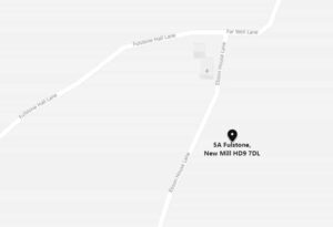
5a Fulstone New Mill HOLMFIRTH HD9 7DL

AFD can provide latitude and longitude coordinates at the property level, showing a pinpoint location of an address. Using the same mapping tool that the driver was being guided by, a search of the property’s geo code found the precise location.
Point of entry address validation would have solved the address issue immediately, and identifying the property with latitude and longitude would have given the accurate delivery location of the address.
This is one example of the cost of error for an organisation not using AFD Software’s address validation solutions.
When this issue is scaled to an organisation making thousands of deliveries a day, the cost of error increases and brand perception plummets.
Can your organisation continue to rely on “free” addressing solutions? What is the true cost when a delivery failure occurs?
